In “chapter one” of the Survival Library, I recommended a number of books on the subject. Many of these are available in free on-line editions.
In the subsequent chapters, other books are to be examined.
One of the things I will be looking at is if these additional titles offer supplementary information to that in the books from chapter one, or handle common topics in a more easily digestible form.
For chapter two, I looked at “Bushcraft 101” by Dave Canterbury.
For chapter three, I read “Practical Outdoor Survival” by Len McDougal.
I will admit, chapter three has been a long time coming. There are a number of reasons for this:
For one thing, Practical Outdoor Survival is in many respects similar to Bushcraft 101.
Both are mainly written for North American outdoorsmen. Both are essentially “what to do if lost in the woods” books, although other environments such as deserts are dealt with.
I wanted to make a fair review of Practical Outdoor Survival without recent impressions from Bushcraft 101 clouding my recollections.
A second delay was that I acquired two copies of Practical Outdoor Survival, one from 1992 and another from 2008. I wanted to read both editions to give a more comprehensive review.
I will start by saying I do think Practical Outdoor Survival is worth a read. In fact, it nicely complements Bushcraft 101.
The 2008 edition naturally includes updated information. For example, we now know that iodine is not 100% effective against waterborne pathogens.
Information on some new products that have become available since 1992 is also included.
We also see an evolution in techniques: In the 1992 version, Len McDougal was carrying his “survival gear” in an LBE massing around 15 pounds. In the 2008 version it has been realized that a backpack is a better way to carry camping gear. Details of the contents of a “day and a half” pack are given.
I will note that often the initiation of an emergency situation is finding yourself unable to access your LBE and/or rucksack. Then you must get by with what is in your trouser pockets, on your belt and in your coat or jacket.
Shelter
The shelter section has some interesting ideas.
Using leaf litter to “thatch” your shelter is a good trick.
Another interesting technique is to use a fire to melt a shelter into deep snow rather than trying to dig one in subzero conditions.
In the 1992 edition is the idea of digging a “den” or “bunk niche” into the side of a leeward earth bank (p.62). For some reason this technique was dropped from the 2008.
Clothing
Sometimes your hands need protection from things other than the cold and rain. McDougal makes the wise recommendation of adding a set of leather work gloves to your outdoor kit.
McDougal also points out that faces also need protection from dust, sand, wind and cold.
Your outdoor kit should already include keffiyeh, scarves, neck gaiters and/or headovers.
One of the woolly hats in your kit should be a ski-mask or the type of balaclava that covers the nose and mouth.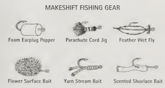
Hunting and Fishing
The sections on hunting and fishing are very good. Adding a “frog gig” to your outdoor gear is a good idea, since such multi-tined spear heads can also be used to fish.
A fishing float improvised from a foam ear plug is interesting.
Unless you are issued them for free, using an ear plug is actually a relatively expensive option. Any small piece of scrap foam, bottle cork or polystyrene could probably be used. Trim corners off kip mat? Use that foam!
Ideally you want a float some distance above the hook, with room to add some shot to weigh the bait down.
Cut a thin slit halfway through the foam, place the line of snood/trace/leader through the slit. Wrap the piece of foam in a few centimetres of bright coloured electrical tape.
I differ with the author on a couple of points:
Carrying multi-vitamins seems redundant. Do not take these unless recommended by your doctor. Problems from vitamin deficiencies take months or even years to develop, so you are unlikely to carry enough tablets to make a significant difference. You can avoid “rabbit starvation” by eating your greens!
As an aside, consequences of hypervitaminosis can be very rapid. You are unlikely to get this from most over-the-counter vitamin supplements. Liver from polar bears or bearded seals is toxic because of high concentrations of vitamin A. Since 100% positive identification (seal of approval?) may be problematic, best avoid the liver of any seal.
Carrying glucose tablets for hypoglycemia detracts from the potential of other sugar-containing foods and drinks that are an equally effective or better treatment.
I don't see the point in carrying a glass heliograph that weighs several ounces when there are cheaper, lighter and larger plastic mirrors available.
Rimfire .22 for Survival
The section on a survival rimfire rifle in the 2008 version is very good, but I disagree with the comment that “first guns should not be semiautomatic”. No justification for this statement is given.
Money is tight for many of us, and the first survival rimfire may be the only one for many years to come!
A semiautomatic means less body motions to alert sharp-eyed game.
Semiautos are also better suited to emergency defensive fire with a .22. Less fumble factor under stress! Defence will rely on rapid, accurate fire.
Openly carrying a firearm may not be prudent in certain locations. A takedown design that can be stowed in a pack has merit, if it has adequate accuracy.
A small game rifle/shooter/ammo combination needs to be capable of reliably taking squirrel‑sized targets.
I also recommend that at least half of your .22 ammo be solids.
In a genuine emergency hunting situation, your .22 rifle may have to be used against targets larger than this chambering is generally recommended for.
Penetration and headshots are a priority.
Hollowpoint rounds for 22s are designed for very small game and will lack sufficient penetration for larger targets.
Hypervelocity loadings such as CCI Stingers or Remington Yellow Jackets and Vipers also need to be carefully considered.
Some authors have noted that the performance improvements these loadings show on paper do not result in a similar;y sized increase in performance in the field.
Tissue damage (aka “loss of meat”) may be greater but shot placement still needs to be effectively the same as a lethal hit for a standard high-velocity .22LR.
Are a few extra yards of range worth what may be a 65% increase in price?
Many hypervelocity loadings are also only found in hollowpoint configuration.
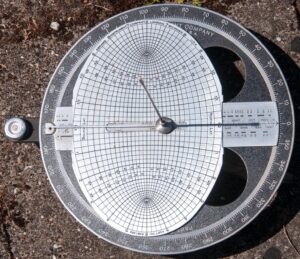
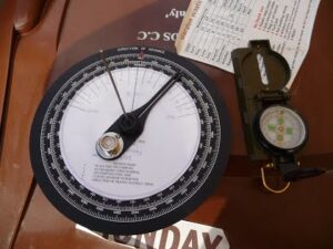
Compass
A comment worth digesting is that “basic orienteering with map and compass can be learned in a matter of minutes”.
The Phillosoph crash course in compass:
1: To find the bearing/heading of a landmark: Point the reference mark of your compass at the landmark. Turn the bezel until the “N” (0 degrees) has the magnetic tip of the needle pointing towards it. The value on the bezel next to the reference mark is the bearing.
Compasses that do not have rotating bezels and reference marks on the body or baseplate are considerably less useful!
2: To find the direction of a desired heading/bearing: Turn the bezel until the desired bearing is next to the reference mark. Move your body until the point of the needle points to “N” on the bezel. The reference mark will be pointing in the desired heading. Pick out one or more landmarks in that direction and walk toward them.
Bonus Lesson: The difference between a bearing and its back-bearing is always 180 degrees.
Method using Arithmetic: If the value of the bearing is less than 180, add 180 to it to get the back bearing. If the value of the bearing is greater than 180, subtract 180 to get the back bearing.
Non-Maths Method: Take a non-ferrous straight edge such as the edge of a map or page. Place the straight edge next to the value of the bearing on the bezel. Make sure the straight edge also passes over the pivot point of the compass needle or card. Where the straight edge crosses the bezel again is the value of the back bearing.
A variant of this technique uses the corner of a page or map to add or subtract 90 degrees from a heading. This may be useful when “boxing” an obstacle.
How to use a map and compass together is another set of lessons. You may like to read my blog on magnetic declination. A number of field manuals explaining how to use a map with a compass are available on-line for free. These include:
I cannot really say which version of Practical Outdoor Survival is better. 2008 is more up-to-date, but 1992 seems to have a few extra ideas and I prefer how some sections are written.
If possible, get both, and read them alongside Bushcraft 101.